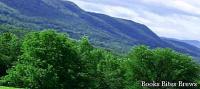
This long granite ridge makes it difficult to meet different civilizations, however it raises its mighty ramparts to the sky, magically inserting them along the path of men who travel the western coast of South America from north to south.
Where is it
Located along the entire South American west coast with a length of over 8000 km, the Andes mountain range constitutes a majestic and massive barrier difficult to overcome.
It was Diego de Almagro, the Spanish conqueror, who ventured into the south of those still unexplored mountains, becoming the first European to try his hand at this adventurous venture.
Instead of gold, he found the Atacama desert, some Inca ruins and the Araucani Indians, who were wild warriors.
Physical characteristics
While the northern part with a curved and dilated trend forms the highlands of Peru and Bolivia, the Argentine-Chilean Andes thin towards the south, until they are divided into a number of islands at the latitude of Cape Horn.
Analyzing the geological history of this massif, we realize that it has been affected by major upheavals in succession, including a Mesozoic continental sedimentation in the ancient Andean basin, thousands of meters thick.
Subsequently, the mountain range underwent a series of successive bending, accompanied by gigantic granitizations, as well as a violent erosion that caused strong flattening and the formation of large foothills.
The current mass of the chain, due to the vigorous orogenesis that occurred at the beginning of the Pliocene, was violently carved during the last Tertiary period.
In the Quaternary, an extensive volcanic activity along all the Andes formed the most beautiful peaks, while the glaciations shaped unusual shapes in the part located further south.
The great diversity of landscapes is mainly due to morphogenesis and current climatic conditions.
La Puna is an immense Argentine basin, located at over 4000 meters above sea level, divided into large compartments where salt forms expanses called salares.
Recommended readings- Brasilia: what to see in the capital of Brazil
- Mexico: useful information
- California (United States): what to see
- Iowa (United States): what to see in the 29th state
- Arches: what to see in the national park
The extremely arid desert that covers northern Chile is transformed by rising in altitude into a cold desert located on the plateau.
The eastern slopes are characterized by a dense forest between 600 and 900 meters above sea level.
At the twenty-seventh parallel the chain thins and includes very high peaks, including the Tupungato and Aconcagua, both close to 7000 meters above sea level.
The climate is very dry on the slopes, while the peaks are often covered with snow and ice, a factor that allows a copious irrigation of Central Chile and the Mendoza foothills area.
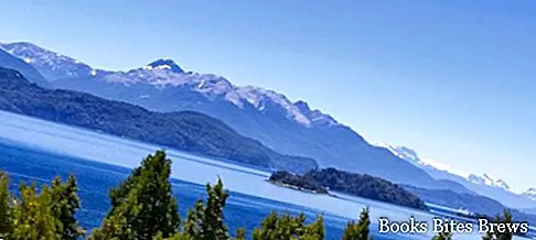
Beyond the 42nd parallel, the temperate oceanic climate and the glacial morphology give the Andes of Patagonia a very different aspect, characterized by the massif, which at that point does not exceed 4000 meters, covered by glaciers.
On the western side, where rainfall is abundant, the perennial forest enriches with new species, including conifers in the north, cypresses and beeches.
On the eastern side, starting from a thousand meters, forest and grassy pasture follow one another.
The Quaternary glaciation resulted in the modeling of the mountains and created long fjords on the Pacific coast, and morainic bars were formed that were able to retain lakes of enormous size, including Lake Buoenos Aires and Lake Argentino.
Tourism
The Nahuel Huapi National Park, around San Carlos de Bariloche, attracts many tourists, fishermen and skiers, thanks to the landscape of extraordinary beauty.
With the exception of some tourist resorts and mines, inhabited areas are scarce.
The Southern Andes are the most inhospitable, as they are excessively massive and even less frequented.