
What to see in Porto Santo, where it is located, climatic characteristics, water temperature, crops, best times to go to the Portuguese island.
Tourist information
Located in the Atlantic Ocean off the coast of Portugal, the island of Porto Santo is located about 50 kilometers north-east from the island of Madeira.
It belongs to Portugal and has an area of 60 square kilometers with just under 5000 inhabitants.
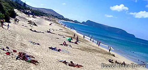
Porto Santo is characterized by a mild climate all year round with temperatures ranging between 18 and 27 degrees Celsius, the south coast with very fine sand and the north coast, on the contrary, rich in cliffs positioned overlooking the ocean.
The temperature of the ocean water around its coasts is never so cold as it is heated by mild underwater volcanic activities.
With rainy phenomena they are infrequent and the presence of dry winds, the vegetation is not very luxuriant also due to the rocky nature of its territory with a prevalence of prickly pears and other types of succulents.
Among the most typical crops there are vines, watermelons and melons.
What see
Vila Baleira is the main city of Porto Santo, where Christopher Columbus lived for a short period, of which it is possible to visit the house.
From Pico do Facho, which with its 516 meters of altitude constitutes the highest elevation, you can see the five uninhabited islets that surround the island.
Although the climate of Porto Santo is mild all year round, it should be borne in mind that the best time to take a beach holiday, with beach life in a bathing suit, is from 1st May to 31st October.


