
Discovering Aconcagua, the highest mountain in the Andes mountain range in Argentina, hints of physical geography and weather characteristics, normal route and alternative routes followed by climbers from all over the world.
Where is it
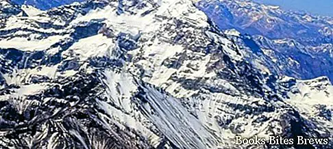
With a maximum altitude of 6959 meters, the Aconcagua represents the highest mountain in the South American continent, bordered to the north by the Los Patos valley, to the south by the Los Horcones valley, to the east by the valleys of the Los Indios and Las Vacas rivers, and west from the Volcano valley.
The Aconcagua, formed by two peaks joined by a short ridge, can be contemplated in all its magnificence from the Los Horcones valley.
This elongated massif in a north-south direction includes other important peaks, including Cerro Cuerno, Cerro Catedral and the Tupungato volcano.
Climatic characteristics
Due to violent storms with low rainfall, the top of Aconcagua is not affected by perennial snow, the snow reaches about 4600 meters on the southern slope and towards 5000 meters on the northern slope.
Physical geography
Analyzing the relief, three parallel orographic lines can be distinguished, of which the first, which offers greater continuity, is used as an international frontier.
The second, called the front Cordillera, is located in Argentine territory and includes the peaks of Aconcagua and Mercedario, which reaches 6668 meters.
The third orographic line, called Precordigliera, rises above the foothills area of Cuyo.
The region of the arid Andes
The name of the arid Andes assigned to this region derives from the great widespread drought, favored on the eastern side by the so-called white wind, a very violent current of air that dries the ground by sweeping away the snow.
The mountain landscape is for this reason desert, characterized by intense brightness.
Geological features
The Aconcagua corresponds to a syncline surmounted by paleogenic volcanic rocks.
Recommended readings- Buenos Aires: what to see in the capital of Argentina
- Ushuaia: what to see in the southernmost city in the world
- Argentina: useful information
- Aconcagua: normal route to the highest peak in South America
- Mar del Plata (Argentina): what to see
The base is formed by corrugated sedimentary rocks, dating back to the Jurassic and Cretaceous, on which there is a block of volcanic rocks.
Perennial snow feeds rich waterways that irrigate the glacial valleys, both on the Chilean and Argentine sides.
To the north are the main tributaries of the Rio Mendoza, in particular the Rio los Horcones, whose two upper arms enclose the very base of the Aconcagua.
Other peaks, including Cerro Cuerno, Cerro Almacenes and Cerro Santa Maria, all around 5000 meters above sea level, also feed, with the numerous glaciers present, the hydrographic system of the country.
The southern side of the mountain is the one characterized by the greatest amount of snow and glaciers, from which the Aconcagua River originates, which flows into the Pacific Ocean, giving its name to the Chilean province that it bathes.
Mountaineering excursions
Climbers from all over the world have always considered the ascent to the summit of Aconcagua an exciting challenge.
The first to attempt the climb was the German Paul Gessfeld in February and March 1889, however, reaching only 6600 meters.
In 1889 it was an English expedition, under the guidance of Fitzgerald, an English explorer, to try his hand but without success.
It was not until January 1897 that anyone succeeded, in which case it was the Swiss guide Mattias Zurbriggen to reach the top, followed in the same year by the expedition organized by Stuart Vines.
With a starting point in Puente del Inca, the normal route followed by Mattias Zurbriggen develops on the northern side, with the presence of refuges up to 6400 meters above sea level.
In 1934 the Aconcagua peak was reached by the Argentine Nicolas Plantamura, while the southern ridge was only climbed in 1953, since it was a very steep wall.
Road and rail connections
Currently, in the Cuyo region of Argentina, it is possible to take the road that reaches Chile through the Andes.
Skirting the Rio Mendoza and crossing vineyards and foothills, this route goes up the valley, with an ever increasing slope between two sides of red rocks, passing through the Cuesta de las Cuevas.
From that point the crossing of the highest area of the Andes begins, reaching up to 4000 meters.
At 3000 meters there is the railway tunnel between Las Cuevas and Caracoles in Chile, built to connect Buenos Aires to Valparaiso.


