
Despite the current problems characterized by progressive melting, a process that began at the end of the nineteenth century, the Aletsch Glacier is considered one of the most beautiful in the Alps, set in a grandiose setting, with a long outpouring of ice that feeds a rushing torrent and a powerful tongue pointed towards the Rhone valley.
Dimensions and altitude
The Aletsch Glacier, nicknamed the Sea of Ice, is the largest in the Alps, covering approximately one hundred and twenty-five square kilometers, followed by the Gorner glacier, the Fiesch glacier and the Mer de Glace.
On the southern side of the Bernese Oberland, the Aletsch Glacier extends for 24 km between the top of the Jungfrau Joch, at 3454 meters, up to its current front, located at about 1650 meters above sea level.
In 1927 the average altitude of the entire basin was 2920 meters, while that of the glacier surface reached 3030 meters, a difference due to the position and shape of the glacier and the valley.
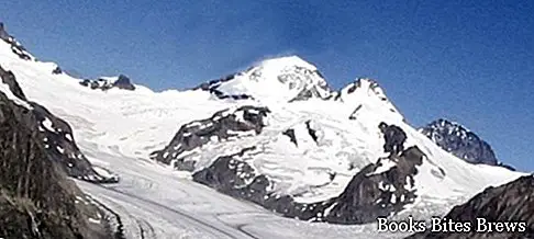
Physical characteristics
The supply basin is formed by three streams of ice, which flow from east to west.
These frozen streams are the Ewig Schene Feld, the Jungfrau Firn and the Grosser Aletsch Firn, converging on the level of the Konkordia Platz, the place where the ice is most concentrated.
On-site measurements in 1950 showed that the ice temperature in the supply basin was around -3 degrees centigrade.
In the same year a tunnel was excavated at 3470 meters to evaluate the behavior of the ice.
Annually an ice volume of around 115 million cubic meters passes through that point, at an average speed of 180 meters per year.
From Konkordia Platz starts a glacial tongue, about 1500 meters wide, which descends towards the south heading towards the Rhone valley.
This glacial tongue in the middle valley does not receive tributaries from the left, while from the right it has received for a long time the contributions of small glaciers, including the Mittel Aletsch Gletscher and the Triest Gletscher.
Recommended readings- Bern (Switzerland): what to see in the capital
- Gorges of the Aare: the power of water between Meiringen and Innertkirchen
- Lucerne (Switzerland): what to see
- Geneva (Switzerland): what to see in 1 day
- Lake Lucerne: tour of the villages of Lake Lucerne
The glacial mass on the left bank has long held Lake Marjelen barring a small adjacent valley, thus avoiding disastrous floods.
Dissolution
Since the early 1900s, the Aletsch Glacier has undergone an intense melting, causing a strong lowering of its surface.
For this reason, huge lateral accumulations of rocky debris gradually appeared throughout the glacial tongue.
But the major changes have affected the front of the glacier, which has never ceased to regress since 1892.
The total size of the regression was about a thousand meters, an event that allowed to find some irrigation channels that had been covered by ice at the end of the medieval era.
The Aletsch Glacier feeds Massa, its emissary stream, used to produce hydroelectric energy in the summer.
Tourism
This natural wonder represents a very interesting tourist destination, with various peaks that attract mountaineering enthusiasts.
In spring the glacier turns into a very popular ski slope.
During the summer, the Aletsch basin, appreciated for the magnificence of its landscapes, can be reached using the Jungfrau train or with the cable car that goes up the Rhone valley.


