
Capricious river with fearsome floods, the Amur is comparable to an open road that flows towards the Pacific Ocean, first crossing the gorges of the plateaus to subsequently disperse in the prairie, flooding the surreal horizons of the wide prairies.
Physical characteristics
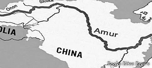
At 4400 km, the Amur is the longest river in Siberia, in eighth place in the world.
It arises from the confluence of two rivers, the Silka and the Argun, descended from the highlands of northeastern Mongolia and Transbajkalia.
The high Amur appears as a mountain river, which opens a passage through the steep gorges of the Gran Chingan massif.
In that stretch the slope is strong, boulders abound in the river bed and the banks are covered with coniferous forests.
Following the course of the river the mountains are lowered, while cedars and broad-leaved trees take the place of fir trees.
The arms of the Amur
At Blagovescensk the Amur is divided into numerous arms, among which the meander of Korsakovo is very particular, where the river makes a 45 km tour to overcome a distance of 600 meters as the crow flies.
Continuing the river, it maintains a slow pace, crossing the plain formed by the affluents Zeja and Bureja.
Once the latter tributary has been assimilated, the Amur encounters a narrow corridor of about 150 km in length, passing through the Little Chingan before exiting the great Sungari plain, another tributary that feeds it with the waters of Chinese Manchuria.
After passing Khabarovsk, the water course widens further, remaining at 70 meters above sea level, about a thousand km from the mouth.
Lower amur
The lower Amur continues expanding into that marshy plain, with many islands filling its course, especially after the entry of the Ussuri, another tributary.
Recommended readings- Thailand: useful information
- Bangkok (Thailand): what to see in the capital
- Oman: what to see between beaches, desert and palm trees
- Hong Kong: useful tourist information
- Tokyo (Japan): what to see in the capital
A last bend, oriented north, guides him into the Gulf of Sachalin, where he disperses into an estuary of enormous proportions.
The slope of the lower Amur is so poor that a wind from the east or a flood at the same time as the Usuri or the Sungari is enough to prevent a sufficiently fast flow of the waters.
For this reason, at the first rain, the flood becomes inevitable, becoming catastrophic in the event that the snow melts early due to the rains resulting from early monsoons.
Since the early 1900s, attempts have been made to stem floods to mitigate their effects.
Navigable river
A very important aspect of the Amur is to be an entirely navigable communication route along its entire course, in addition, fish abound.


