
How to get to the Mal di Ventre island, where it is located, territorial extent and type of vegetation, geological features, marine fauna and archaeological finds, what to see.
Tourist information
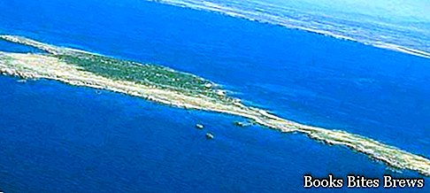
The Mal di Ventre island and the Catalano rock are located in the sea west of the Sinis peninsula, a peninsula of central western Sardinia and are part of the protected marine area Sinis Mal di Ventre.
The island, which belongs to the Municipality of Cabras in the province of Oristano, has a reduced extension of territory, just over a square kilometer.
It is considered by many to be an earthly paradise of rare beauty, devoid of inhabited centers and covered by a low scrub made of cistus, mastic, rosemary and tamarisks, populated only by animals.
Mal di Ventre is granite in nature, its highest point is 18 m. above sea level, it is made up of rocks eroded by the wind, shaped in various shapes by the force of nature, by small and pretty beaches, by a rather low vegetation due to the incessant blowing of the mistral wind, and is surrounded by a crystal clear sea with very deep backdrops beautiful, with a great variety of fish, sea turtles, molluscs and crustaceans.
There are also numerous birds that stop or nest on the island.
In addition, the island holds interesting archaeological evidence relating to a human settlement from the Nuragic era.
How to get
To get to the island you can do it with your own boat or for hire, or take advantage of the shuttle service available in the summer months with some daily round trips.


