
Located in the South West of Europe between France and Spain, the Pyrenees mountain range constitutes a formidable barrier between the Iberian Peninsula and the European continent.
Tourist information
The principality of Andorra lies between the peaks.
Parts of six French departments and six Spanish provinces are in the Pyrenees region.
Perpignan, Bayonne, and Orthez in France and in Girona, Huesca, Pamplona, Spain and Irún are other important cities.
The Franco-Spanish border, unchanged from the Pyrenees Peace (1659), generally follows the watershed.
The high stage of civilization reached in the Pyrenees by early humans demonstrate the prehistoric cave paintings of Altamira and Aurignac.
The chain extends in a straight line for almost 435 km from the Bay of Biscay to the Mediterranean Sea and its maximum width is 130 km.
About two thirds of its surface is located in Spain.
Of the three main sections of the Pyrenees, the central section is the one with the highest altitude.
The Pico de Aneto in Spain is the highest peak, other peaks are the Pic de Vignemale and the Pic du Midi d’Ossau in France and Monte Perdido in Spain.
The Cantabria mountains are a western extension of the Pyrenees.
Recommended readings- Champagne Ardenne (France): what to see in the region
- Spain: travel story between Toledo, Andalusia and Madrid
- Saint Tropez (France): what to see
- Barcelona (Spain): what to see in the capital of Catalonia
- Burgundy (France): what to see in the region
The Pyrenees were formed during the Tertiary period.
Crystalline rocks are found in the highlands, while limestone rocks are highlighted in the lower slopes.
Of glacial characteristics in the distant past, today in the Pyrenees there are no glaciers.
The limit of permanent snow is at an altitude of 1,830 m.
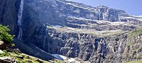
A feature of the French Pyrenees, which have a much steeper south slope, are the streams that often fall into waterfalls, and the natural amphitheatres known as circuses, including the famous Cirque de Gavarnie.
The most important rivers are the Garonne, the Aude, and the Adour, while the Spanish rivers of the Pyrenees include the Aragón, the Cinca, and the Segre. The Pyrenees represent a climatic division.
In fact, the northern slopes receive abundant rainfall, while the southern slopes enjoy a less rainy climate.
Routes of communication
The Pyrenees are crossed by two railway lines, but the main railway lines that connect Spain with France along the Pyrenees along both coasts.
A number of roads cross the Pyrenees, including the main ones that use three tunnels while four cross high mountain passes often covered in snow in the winter months.
Most of the mountain passes are at high altitudes and difficult to travel, but despite this they have often been crossed by invading armies and barbarian hordes as well as by countless medieval pilgrims heading to Santiago de Compostela.
The Col de Perthus, used by the Romans, and Roncesvalles, famous for the Roland legend, are the most popular passes.
Economy
The Pyrenees are rich in timber and pastures, and the numerous streams are exploited by hydroelectric plants.
Talc and zinc are extracted here. The population lives mainly on cattle breeding and agriculture.
On the French side there are the most famous places, including Pau and Tarbes, famous for the beauty of their landscapes and for the mineral waters.
Lourdes, one of the main pilgrimage sites, attracts millions of pilgrims every year.
On the Atlantic coast, under the Pyrenees, there are trendy resorts including Biarritz, Saint-Jean-de-Luz in France and San Sebastián in Spain.


