
What to see in Utah, information including geographic and climate news, landscape features and neighboring states, main cities.
Tourist information
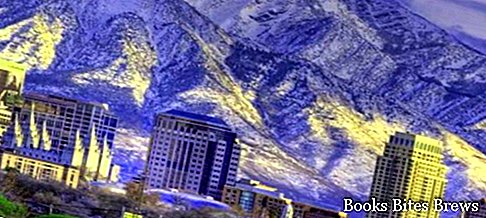
Utah is one of the states in which the United States of America is divided, located in the western area of the Rocky Mountains with the capital Salt Lake City, a city that takes its name from the Great Salt Lake located in the immediate vicinity.
The neighboring states are Idaho, Wyoming, Colorado, New Mexico, Arizona and Nevada.
In the central part of the state there is the Wasatch Range mountain range with quite high peaks.
It is no coincidence that in these mountains it snows a lot during the winter months and for this reason they are the ideal destination for those who love skiing.
Other important mountains located in the north-eastern sector are the Uinta Mountains which touch on average four thousand meters and of which the highest peak is Kings Peak with its 4,123 meters.
Utah's climate is largely arid with few rainy phenomena during the year.
Large thunderstorm showers occur in summer and autumn, which can cause floods and fires due to electrical lightning strikes.
What see
The natural landscape of Utah is very varied, ranging from arid deserts characterized by frequent sand dunes and lush coniferous forests in the wide valleys between the mountains.
The Wasatch Front is an area located in the western part of the Wasatch Range region and is formed by a set of valleys and basins where most of the population resides.
The main cities are Ogden, Salt Lake City, Layton, West Valley City, Sandy, West Jordan, Orem and Provo.


