
Useful information on the Aegean Sea, where it is located, depth, subdivision of the homonymous region and archipelagos of islands that are part of it.
Geography of the Aegean Sea
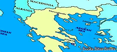
The Aegean Sea is a portion of the Mediterranean Sea between the east coast of Greece, the island of Crete and the west coast of Asia Minor.
It communicates with the Marmara Sea and the Black Sea through the Strait of the Dardanelles.
At the deepest point it reaches 2591 meters deep, precisely north of the island of Karpathos.
The Aegean Sea is bordered to the south by the islands of Crete and Rhodes and represents one of the nine geographical regions into which Greece is divided.
The Aegean region is divided into two parts, the North Aegean and the South Aegean, both bordering Turkey to the east.
The coasts washed by the Aegean Sea are very articulated with frequent groups of islands, including the Cyclades and Sporades archipelago.
Another important group of islands in the Aegean Sea is represented by the Dodecanese consisting of several islands including the island of Rhodes, Calchi, Caso, Coo, Lero and Stampalia.
The main ports on this sea are Thessaloniki, Piraeus and Smyrna.


