
What to see in the Great Basin, itinerary through this region of the United States with particular geological characteristics, including Desert and Great Salt Lake.
Tourist information
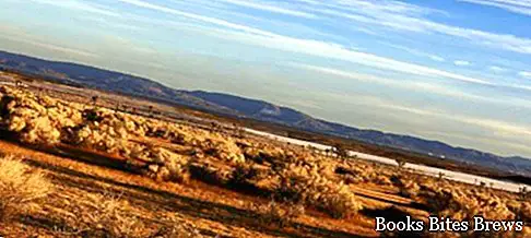
The Great Basin encompasses a large region in the western part of the United States, enclosed between the Columbia Plateau to the north, the Wasatch mountain range that forms part of the Rocky Mountains to the east, the Cascade Range, and the Sierra Nevada to the west.
The formation dates back to about two million years ago following vertical upheavals of the earth's crust which caused the lifting of a vast sedimentary clod.
It consists of various mountain ranges with heights between 1200 and 1500 meters, with elongated depressions and some lowland areas mixed with reliefs here and there.
The territory of this region covers an area of about half a million square kilometers and almost completely occupies the state of Nevada and western Utah.
What see
The Great Basin Desert is largely occupied by salty lake basins, including the Great Salt Lake, and by some deserts such as the Black Rock Desert, that of the Great Salt Lake and the Mojave.
The arid climate does not favor vegetation and the small amount of water that is collected in this area does not come to flow towards the sea as well as the rivers, of which the largest is the Humboldt, which along the course are also dispersed by evaporation.
It is a large area called endorheic, as no water course reaches the ocean.
At the center of the Great Basin there is a vast depression that represents the bottom of Bonneville, a prehistoric lake, of which the last traces remain in the Great Salt Lake and in the Sevier and Utah lakes.


