
What to see on the Aeolian islands, which island of the archipelago to choose, list with description of the natural and historical characteristics of each island.
Tourist information
Volcanic archipelago located in the Tyrrhenian Sea, the Aeolian islands are located off the northern Tyrrhenian coast of Sicily, in the province of Messina.
The islands, bordered by various islets and rocks, in order of size are Lipari, Salina, Vulcano, Stromboli, Filicudi, Alicudi and Panarea.
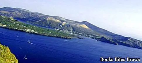
– Lipari, the largest island, is located in the center of the archipelago.
Its position offers the possibility to easily reach the other islands of the archipelago, taking advantage of various maritime connections.
From an administrative point of view, all the Aeolian islands, excluding Salina, depend on the Municipality of Lipari.
The island, with its rough and rough shapes, reaches its maximum altitude with Mount Chirica 602 m. s.l.m .. The coasts are high and jagged in the western part and low in the eastern part.
The fumaroles, of which the best known are those of Bagnosecco, the thermal springs, of which the most relevant are the ancient Baths of San Calogero, and the pumice of Monte Pelato, recall the volcanic nature of Lipari and constitute evidence of the eruptions that took place in ancient times.
The main inhabited centers of the island are Lipari, Pianoconte, Canneto, Quattropani and Porticello.
The capital Lipari extends along the inlets of Marina Lunga and Marina Corta, at the foot of the Castle, a natural fortress consisting of a rhyolithic base on the top of which various civilizations have followed over the millennia.
The current appearance is characterized by the walls that enclosed the city, erected by the Spaniards in the sixteenth century.
Recommended readings- Mazara del Vallo (Sicily): what to see
- Trapani (Sicily): what to see
- Randazzo (Sicily): what to see
- Milazzo (Sicily): what to see
- Sicily: Sunday day trips
Of the old urban center, the Churches remain, very interesting, in particular the Cathedral of Norman origin, the ancient Palazzo dei Vescovi and some buildings where the rich Aeolian Museum is housed, divided into different sections, which collects material from numerous excavations carried out in the Aeolian islands.
At the Castle there is an important archaeological area, the result of excavations that have brought to light some layers of buildings, ranging from the sixteenth century BC. to the Roman age.
Marina Corta is a very suggestive corner of the island of Lipari, where there is the Ugo di Sant'Onofrio square, known as Marina Corta, characterized, on the sea side, by a small peninsula, where the Church of the Souls of Purgatory stands , also known as Madonna della Neve, as shown by some historical documents, which attest to the origin of its construction in the period before 1545, the year in which it was rebuilt after the destruction caused by the pirate Kair el-Din called Barbarossa.
Piazza di Marina Corta, where bars and restaurants overlook, is a very popular place on summer evenings, especially on the night of August 24, the feast of San Bartolomeo patron of Lipari, when, after the procession with the statue of the saint, the feast ends with spectacular fireworks over the sea.
– Salina it takes its name from a salt water pond located south of the island, formerly used for the extraction of salt.
From an administrative point of view, the island is the only one of the islands in the archipelago that does not depend on Lipari, but is divided into the three autonomous municipalities of Leni, Malfa and Santa Marina.
In Salina there are the highest mountains of the archipelago, Fossa delle Felci, m.961, and Monte dei Porri, m. 860.
They are now extinct volcanoes that form two groups of reliefs, Monte Fossa delle Felci and Monte Rivi to the east, Monte dei Porri to the west, separated by the depression of Valdichiesa.
On the island the vegetation is lush, the land is used for the cultivation of capers, fruit trees and vineyards.
Famous is the production of malvasia.
Malvasia grapes and capers are the Aeolian products. Salina acquired notoriety also through the scenes of the film, Il Postino, which the great Massimo Troisi shot on this island.
– Volcano, separated from Lipari by a stretch of sea less than a kilometer wide, called the Bocche di Vulcano, is completely formed by volcanic rocks.
The highest point is an inactive volcano, Monte Aria, m. 500 slm. which together with Monte Saraceno represent the original volcanic building.
To the north west, smaller in size, is the Lentia volcano, whose internal collapse partly generates the Fossa volcano, whose crater located at a height of 386 m., Currently manifests itself with an intense fumarolic activity.
Its last eruption dates back to 1888-1890. Joined to the island of Vulcano by an accumulation of sand, there is the peripheral complex of the volcano cones.
The natural environment is characterized by gorse bushes, ash and lapilli soils, black sand beaches and a thermal mud pond.
What see
– Stromboli it is characterized by a volcano in persistent activity. The eruptive vents are located at an altitude of about 700 meters, the material that is thrown into the air by intermittent explosions and the levers of periodic eruptions, descend to the sea through the steep slope of the Sciara del Fuoco, while on the top of the volcano, at 926 meters, there is what remains of the ancient crater.
On the volcano Excursions are organized with the help of expert guides.
Access to the trails is subject to rules and may vary in relation to the state of activity of the volcano, however, in any case it provides for accompaniment by authorized guides for access to higher altitudes.
The show at night is very suggestive.
The two inhabited centers are Stromboli, along the north east coast, and Ginostra, along the south west coast of the island.
Stromboli, whose ancient inhabited area extended along the beaches of Scari, Ficogrande, with its black sand beach, and Piscità, today also includes a more internal area where the Church of San Vincenzo Ferreri is located, from whose square it is possible to appreciate a beautiful view of the sea, including the rock of Strombolicchio and the Church of San Bartolo, located above the town of Piscità.
Along the coast there are high cliffs and beaches until you get to Ginostra, a characteristic village that has maintained the typical elements of Aeolian architecture, reachable only by sea through the tiny port of Pertuso.
In front of the northern coast of the island, surrounded by clear waters, the Strombolicchio rock emerges from the coral seabed, the remains of one of the oldest volcanic eruptions in the archipelago. Through a steep staircase carved into the rock it is possible to reach the top where there is a lighthouse.
– Filicudi it is the fifth largest island of the Aeolian archipelago.
The maximum height of Filicudi is represented by the Fossa delle Felci mountain, 774 m. s.l.m., an extinct volcano, inactive like the other eruptive centers identifiable on the island, from the oldest Filo di Sciacca, to the most recent of Capo Graziano and Montagnola.
The coasts are mainly sheer above the sea, furrowed by skiing and inlets, where the volcanic nature, the erosion of atmospheric and marine agents, have produced scenarios of spectacular beauty, such as the suggestive cave of the Bue Marino, near Punta Perciato.
North-west of Filicudi, the rocks of Montenassari, the Notary, the Mitra, from the sea, particularly loved by those who practice scuba diving, also emerge near the coast, between enchanting bays with crystal clear water, the rock of the Giafante.
Filicudi is also very interesting from an archaeological point of view.
South-east of the island, in the Capo Graziano peninsula, south of the harbor plain, there are the remains of prehistoric settlements dating back to the Bronze Age.
On the Montagnola hill, dating back to the previous one and in a better defensible position, you can admire the remains of another prehistoric town.
The village is believed to have suffered violent destruction in the thirteenth century BC. and, following this catastrophic event, the island remained uninhabited for a long period.
Today in Filicudi there are small inhabited centers and two docks, Pecorini Mare and Filicudi porto.
Ancient paths, mule tracks in beaten earth or paved in stone cross the island and are irreplaceable to reach its enchanting places.
– Alicuidi it is the westernmost island of the Aeolian archipelago.
It is an extinct volcano whose base develops from 1500 meters below sea level to reach 675 meters above sea level on Monte Filo dellArpa.
It has an almost perfectly circular shape, there are no inlets, its slopes steeply slope towards the sea with steep and steep coasts.
Only on the eastern side of the island, the only less steep, were houses built.
Here is the only inhabited center, Alicuidi Porto.
Along the steep paths we meet, in splendid panoramic points, the Chiesetta del Carmine, the Church of San Bartolo, patron of the Aeolian islands, and the various districts from the typical rural houses, up to Montagna, the last location before reaching the top of Monte Filo dell'Arpa, the highest point of Alicudi.
Instead of the roads there are mule tracks and steps of lava stone, which, immersed in a nature full of charm, climb up to the top and arrive everywhere.
They are passable on foot, or with donkeys and mules, the only means of transport that can be used on the island.
Alicudi, inhabited since prehistoric times, remained almost completely uninhabited in the Middle Ages, due to pirate raids and repopulated after 1600.
As evidence of the attacks of the Saracen raids, in an impervious area there is the female timpune, a place where women and children went to take refuge.
– Panarea it is the smallest and least elevated of the Aeolian islands, reaches its highest point with the 421 meters of the Timpone del Corvo.
Panarea, together with the islets of Basiluzzo, Dattilo, Lisca Bianca, Lisca Nera, Bottaro and the Spinazzola, Panarelli and Formiche rocks, forms a small archipelago, which represents the outcropping part of one of the largest and oldest volcanic basins of the Aeolian archipelago , today almost completely submerged and eroded by the sea.
Currently volcanic activity is manifested through the phenomenon of fumaroles at the Calcara beach and gaseous emissions in the waters between the islets of Lisca Bianca and Bottaro.
The western and northern part of the island is characterized by inaccessible coasts, very high and with a strong inclination, while the eastern and southern part has coasts with a lower height, with beaches, flat areas and ancient terraces, used in the past for cultivation of the vine and the olive tree.
The inhabited centers of the island are Ditella, San Pietro and Drautto.
In the San Pietro district there is the main landing of Panarea, in front of which the welcoming village of San Pietro develops, with its typical white houses.
Continuing towards Drautto, along an ancient and suggestive path, you reach the promontory of Capo Milazzese, where you can admire the remains of a prehistoric village, dating back to the Bronze Age.
From here begins the descent to the beautiful beach of Cala junco, enclosed between two high rocky walls and bathed by crystal clear waters.


