
The story of a trekking excursion to the Tambura pass following the route of via Vandelli starting from Arnetola in the municipality of Vagli di Sotto.
Passo Tambura Apuane
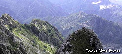
Here is one of my many trekking excursions in the mountains, this time at the Tambura Apuane Pass, one of the highest mountains in the Apuan Alps with its 1891 meters of altitude.
Located along the border line between the provinces of Lucca and Massa Carrara, it is included in the territory of the Apuan Alps.
I walked the path that starts from Garfagnana, in the province of Lucca, in Arnetola, located 900 meters above sea level, which can be reached by car following the paved road, shortly after passing the town of Vagli di Sopra in the municipality of Vagli di Below where, among other things, is the famous dam of the artificial lake of Vagli, created in 1947 with the barrier of the waters of the Edron torrent, submerging the town of Fabbriche di Careggine in order to produce electricity.
For information, this lake is periodically emptied, every 12 years or more, to carry out regular maintenance of the dam, and this attracts tourists and excursionists who want to see the submerged country, which returns on that occasion to be visible again.
Returning to the path marked by the CAI, I followed the 35, which follows the old route of the Via Vandelli, arriving at the Tambura pass where the panorama is truly spectacular, try it to believe it.


