
Definition of latitude and longitude, how these imaginary lines represented on geographical maps are calculated and what they are used for.
Meaning of latitude and longitude
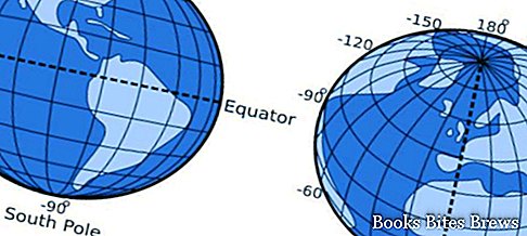
Latitude and longitude are the lines drawn on a map or on a world map, they are also called geographic coordinates.
The lines that go from north to south are those of longitude while the lines those that go from east to west are those of latitude.
Their meeting point allows navigators to determine the position of their boat.
Latitude represents the angular distance of the point considered from the equator line, while longitude is the angular distance of a point from the reference meridian, fixed by convention at the Greenwich observatory in England near London.
Share "What are latitude and longitude, how are they calculated"

